


Great news! March snowstorms bolstered Colorado’s snowpack, and as of April 1st it was at 109% of the 30-year norm. And we still have a few weeks of possible additional snowstorms before melting intensifies. In a Denver Post article, National Weather Service meteorologist Caitlyn Mensch says: “We’re sitting pretty right now. We’re above 100% everywhere, which is positive to see as we head into spring.”
We’re not likely going to have a banner year like 2023 on the Dolores River, but the Four Corners Guides crew is still heading into 2024’s spring with some serious stoke. And we’ve got a bunch of courses on the 2024 schedule!
Check out some of these USGS graphs of historic river levels (below), when things will start happening, and how you can take advantage of the flows in the Four Corners on some of our courses!
In this blog, we’re specifically including rivers for which we have permits: the Animas, the Dolores River and one section of the San Miguel River. We also recently acquired permits for the Colorado River from Castle Creek Road, near Moab, Utah, to the border of Canyonlands National Park. However, we will delve into the possibilities for that river in another post.
There are plenty of other rivers in the Four Corners to explore. We highly recommend you download the American Whitewater app for your phone and do some research!
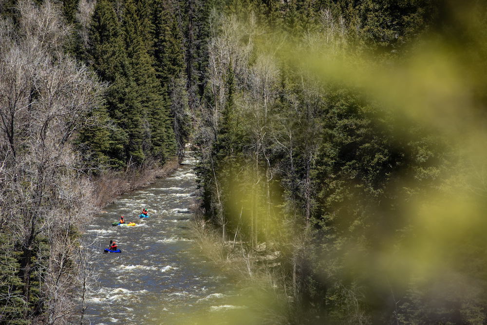
What are Colorado packrafting courses on the Animas looking like for 2024? Awesome. But then again, the Animas is always awesome most of the year for packrafters. The beauty of our local river is you can still develop your skills on it in a packraft in water as low as 182cfs.
April 1st and 2nd, the whole Four Corners Guides guiding crew spent two days in the Animas Kayak Play Park at Santa Rita Park in Durango, doing a joint staff-training and Level 2-4 American Canoe Association Instructor Training. Thad Ferrell and Steve Fassbinder got their Level 4 Instructor certifications, while Lizzy Scully, Tyler Marlow and Ben Phillips got their Level 2 certifications, under the tutelage of one of the world’s best paddling instructors, Kent Ford.
But looking forward to the next few months… as temps warm in the La Platas, the Animas River will likely run anywhere from 800-2000 toward the end of April into May. It tends to rise further, averaging 3000-4500cfs later in May and then into June, though it hit almost 7000 June 10 2019!
At the end of June into July, the river starts falling again to under 1000. Of course, new snowstorms can happen late into the spring, and if it rains, that’s another boost to river levels. We run a full schedule of Level 1-4 packrafting courses on the Animas from April-July, as different sections are appropriate for different level courses.
Let’s cross our fingers for summer monsoons, which mean bigger flows and the opportunity for more advanced boaters to do the Upper Animas or Rockwood (though we don’t guide those sections. Sorry!)
Echoing the Dolores River Boating Advocates (which is a great source of information and is an organization we recommend you join!), we eagerly await more information on the possibility of a release below McPhee Reservoir. Last year we were able to run more than a half dozen personal and guided trips through July, even repeating some sections at different flows just because we could.
The “River of Sorrows” offers such a special and spectacular series of wilderness runs for those lucky enough to catch its flows. It passes through what feels like a high alpine forest all the way down to where tall sandstone walls and towers line a desert riparian landscape. There are Ancestral Puebloan ruins along the way, beautiful side hikes, clean camps that get scoured whenever the river floods, and the full range of Class I-IV rapids (even a Class V). It seems likely with the snowpack that we’ll at least get a short flow. 🤞🏻
Dolores River flows at the town of Dolores don’t adequately represent flows on the entire section of river from Rico down to town because many smaller rivers feed into the main Dolores along the way. However, it still offers paddlers insight on what sections they can run. Just remember that if flows are 1000 by the town of Dolores, they’re likely significantly smaller up in Rico.
For example, during our 2023 banner year for flows, the discharged cubic feet per second (aka “cfs”) down by the town of Dolores was 4580cfs on May 17, 2023, which is HUGE! However, up by Rico on that same day flows reached just 806cfs, which is still great for paddling that section, but clearly significantly smaller. And consider that on August 1, 2023, it was 192cfs, which is OK for paddling, though you’ll definitely hit some rocks. At the same time, August 1 Rico flows fell to just under 87cfs, which is not sufficient for even a packraft to paddle without dragging your butt across rocks for miles.
Regardless of whether or not the section below McPhee runs, we are still lucky that the river runs above the town of Dolores and below the confluence of the San Miguel and the Dolores every year. American Whitewater breaks the section above the town of Dolores into two distinct runs:
Below McPhee, American Whitewater specifies four sections of the Dolores to the Utah-Colorado Border. And we’re including the section of the San Miguel from Naturita down that runs into the Dolores, as we run bikerafting and packrafting courses on that section of the river every year.
And then there’s the Naturita put-in on the San Miguel River to the Dolores Confluence (Uravan), Class I, 21.7 miles, which we generally run through the “Hanging Flume” section on the Dolores River, to some more obscure takeouts.
We hope this gives you an overview of what this year might hold for us!